Camouflaged Gecko
I was moving an old pile of timber out in the back yard over the weekend, hiding in amongst it were 2 Broad Tailed Geckos. I only actually saw one, which had dropped it tail and run off. I knew there was at least one other as there was a second tail writhing about on the ground. The tails moved as though they were alive, made me wonder if they can drop their tails at will as a diversion when they sense they are about to be preyed upon.
I’d placed my jacket on the ground while I was working, when I picked it up a few hours later this guy fell out! Geckos look cool and I always like to see them, I was extra impressed with how effective it was camouflaged against the natural sandstone.

Igneous Dyke near Brooklyn
An igneous dyke is where molten magma has forced it’s way up into a crack between existing rocks. Dykes can extend for many kilometers in lines on the surface. There’s a dyke marked on the Sydney 1:250,000 geological sheet that cuts across the M1 and old pacific highway just south of the Hawkesbury River. It’s mentioned in the “Geology along state highways” section of The Field Geology of NSW. I’ve tried to spot it many times while driving down the M1, I think I’ve seen it but it wizes by so fast it’s hard to be sure.

Silvereye
Zosterops lateralis
Another common bird that I’ve only recently identified in the backyard. The Silvereye gets it’s name from the distinct patch of white around it’s eyes. It’s a small bird, only 11cm – 13cm in length, it moves about quickly making it hard to spot and identify. Silvereye live on the coast and adjacent inland areas of almost all of the country, they’re also found throughout New Zealand and southwest Pacific islands including Lord Howe, Fiji and Vanuatu.
New Holland Honeyeater
Phylidonyris novaehollandiae
Another ( former ) unknown bird in the yard. It’s a New Holland honeyeater, a not uncommon bird that’s distribution stretches from the southern Queensland coast, all the way down the east coast, throughout Tasmania, then westwards following the mainland coast wrapping up a few hundred km north of Perth. They’re small birds reaching a maximum size of 20cm. This one was hard to photograph, it kept moving about, not staying still for long at all.
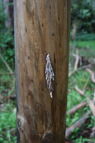
Saunder’s Case Moth Cocoon
Metura elongatus
This cocoon was on a post at the start of the Little Blue Gum Creek walk. It’s large, about 15cm long, with sticks woven into the sides. I remember seeing many like this when I was growing up but had never known what animal made them.
Saunder’s Case Moth Cocoon at the start of the Little Blue Gum Creek boardwalk.
A quick search pointed to it being a Saunder’s Case Moth cocoon. During their caterpillar phase case moths make their cocoons out of silk, most species attach sticks, leaves or other debree as camouflage. Each species had a distinct type of cocoon, but they are also constrained by available materials so even within a single species cases can vary in materials and appearance.
Little Blue Gum Creek Boardwalk
I really enjoyed looking at the photos of the construction of Lady Game Drive, something that kept popping up in them was Little Blue Gum Creek. I must have driven down there a million time but I couldn’t place it.
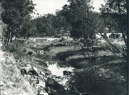
Little Blue Gum Creek : Lane Cove National Park (1939 ?)
After a quick search I found were it is, and also that there is a short boardwalk through the bush at the creek. It’s nearby so in between rain showers last weekend we ducked down there with the kids to take a look.
Old photos from the Ku-Ring-Gai area
Ku-Ring-Gai library has been posting old photos from the area ( including some from Garigal ) to it’s Flickr account . What a great way to make access to it’s archives more convenient. I didn’t even know the library had the photos until I came across one of their online postings by fluke when searching for pictures of Bungaroo.
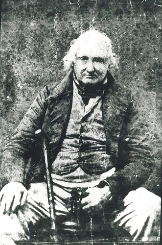
William Henry, the first settler in the Lane Cove Valley. circa 1860.
Swimming pool at the Cascades
The Cascades is located at the junction of Middle Harbour and Frenches creeks inside Garigal National Park. Here both creek beds open from narrow winding channels onto wide expanses of potholed and weathered sandstone. It’s a picturesque and popular location with 3 well maintained fire trails leading into the area from Belrose, Davidson and St Ives. In another exchange with John I learned that the Cascades has an interesting history. As a depression era work project a dam wall was built at the base of one of the two large natural pools to create a large public swimming pool. John sent a photo of how it looked when it was in operation. It reminds me of the ocean pools that occupy the rocky headlands of the nearby northern beaches.
Samphire
Sarcocornia quinqueflora
“A small, erect, leafless herb with succulent stems” - NPOS p. 396
I came across this field of samphire in the salt flats of Moores Creek. I was there looking for remains of a footbridge from an old photo that was supposedly built during WWI as part of a military training exercise. There was no evidence of a bridge, and the creek looked different enough from the photo that it made me doubt I was in the right place.